Product Descriptions
Maximum Streamflow
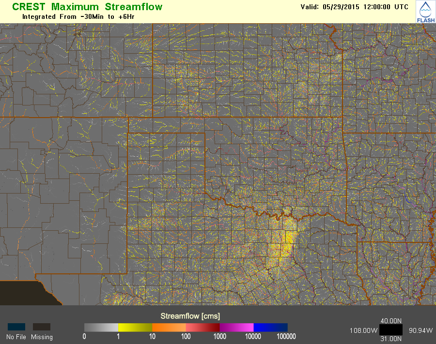
| Product: | Simulated surface water flows (max between 30 min before and 12 hr after the valid time) |
| Units: | m3 s-1 |
| Resolution: | 0.01 deg x 0.01 deg; 15 min |
| Availability: | CONUS-wide |
| Input: | MRMS radar-only QC’ed precipitation rate |
| Usage: | Use this for model diagnostics. Areas appearing in gray and yellow are where rain is currently occurring/overland flows are being modeled. Channel flows tend to appear in purple and blue. |
Maximum Unit Streamflow
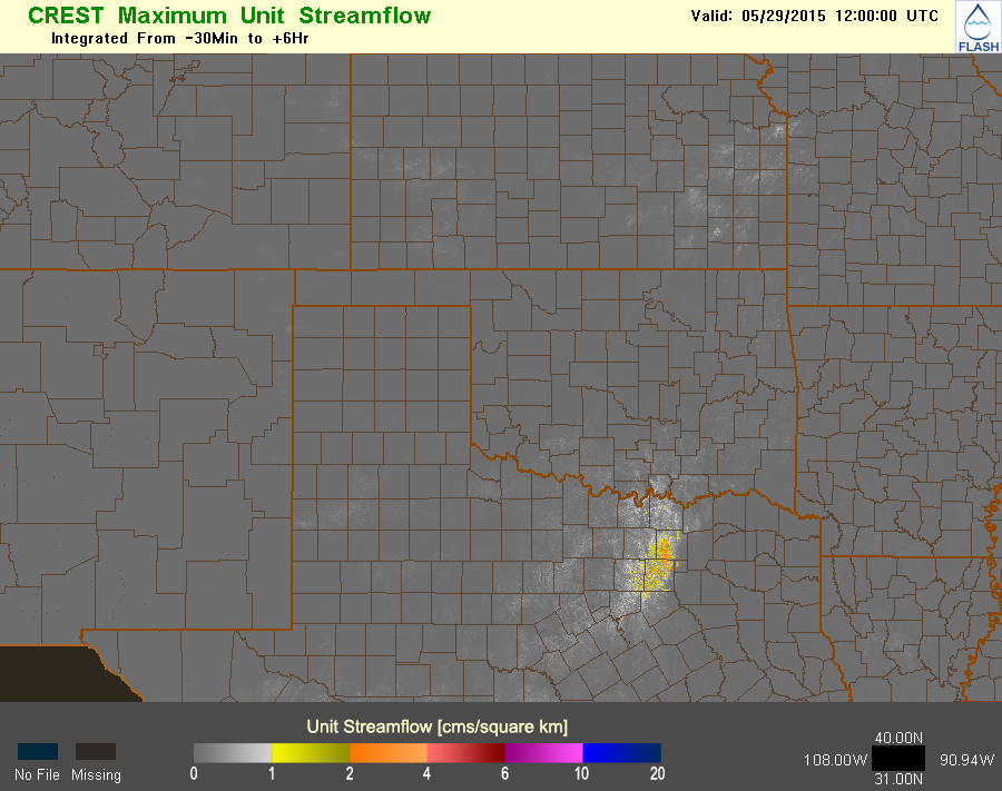
| Product: | Simulated surface water flows normalized by drainage area (max between 30 min before and 12 hr after the valid time) |
| Units: | m3 s-1 km-2 |
| Resolution: | 0.01 deg x 0.01 deg; 15 min |
| Availability: | CONUS-wide |
| Input: | MRMS radar-only QC’ed precipitation rate |
| Usage: | |
Maximum Threshold Exceedance
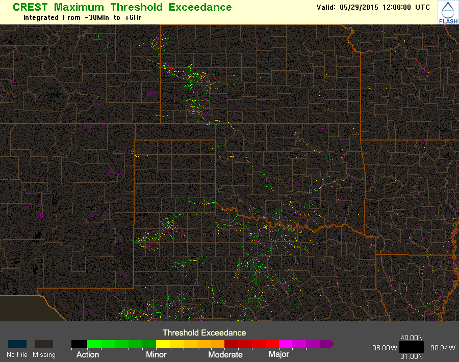
| Product: | Simulated threshold exceedance of surface water flows |
| Units: | unitless |
| Resolution: | 0.01 deg x 0.01 deg; 15 min |
| Availability: | CONUS-wide; cells with drainage areas greater than 5 km2 only |
| Input: | MRMS radar-only QC’ed precipitation rate |
| Usage: | |
Soil Moisture
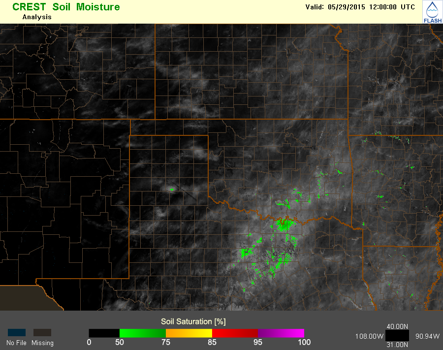
| Product: | Soil moisture content |
| Units: | % |
| Resolution: | 0.01 deg x 0.01 deg; 15 min |
| Availability: | CONUS-wide |
| Input: | MRMS radar-only QC’ed precipitation rate |
| Usage: | Areas with higher soil moisture content will generate more surface runoff for a given precipitation rate thus higher potential for flash flooding |
Precipitation Return Period
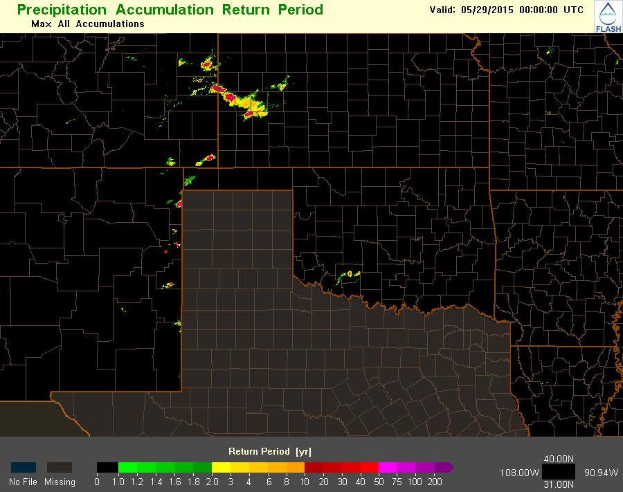
| Product: | Precipitation return period |
| Units: | years |
| Resolution: | 0.01 deg x 0.01 deg; 5 min |
| Availability: | CONUS-wide minus Texas, Washington, Oregon, Idaho, Wyoming, Montana |
| Input: | MRMS radar-only QC’ed precipitation rate, NOAA Atlas 14 Precipitation Return Periods, and Cornell New York & New England Extreme Precipitation dataset |
| Usage: | Extreme precipitation return periods are likely to overwhelm small streams and infrastructure |
QPE-to-FFG Ratio
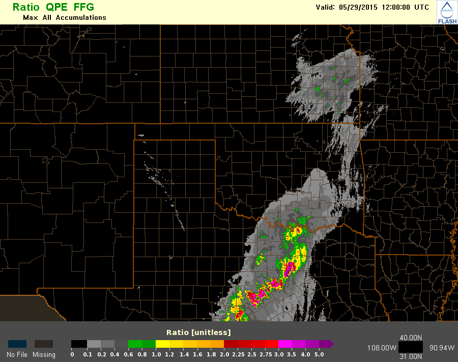
| Product: | Ratio of QPE to FFG |
| Units: | unitless |
| Resolution: | 0.01 deg x 0.01 deg; 5 min |
| Availability: | CONUS-wide minus coastal Washington, and coastal Oregon |
| Input: | MRMS radar-only QC’ed precipitation rate, and RFC FFG grids |
| Usage: | When QPE + QPF exceeds 100% of FFG, bankfull conditions on small natural stream networks exist. |
Precipitable Water
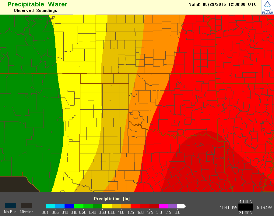
| Product: | Precipitable water |
| Units: | in |
| Resolution: | 0.01 deg x 0.01 deg; 00Z & 12Z for obs; 1-hourly for RAP |
| Availability: | CONUS-wide |
| Input: | CONUS RAOBS, RAP |
| Usage: | Higher PWAT values are associated with a greater probability of heavy rain and thus, flash flooding |
Precipitable Water Standardized Anomaly
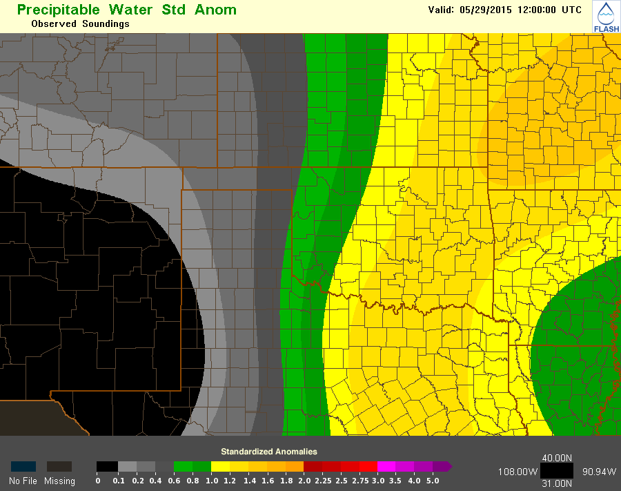
| Product: | Precipitable water anomaly |
| Units: | unitless |
| Resolution: | 0.01 deg x 0.01 deg; 00Z & 12Z for obs; 1-hourly for RAP |
| Availability: | CONUS-wide |
| Input: | CONUS RAOBS, RAP, RAOB PW climatology |
| Usage: | Values 2.0 or higher suggest heavy rainfall is possible. Values above 3.0 have been associated with major flash flooding events. |
Hydrologic Model Descriptions
USGS
observed streamflow
CREST
Coupled Routing and Excess Storage (CREST) distributed hydrologic model that uses forcing from MRMS radar-only rainfall rates at 5-min resolution. Water balance is the CREST model with kinematic wave routing. This configuration uses “nudging” based on the observed streamflow, so is not independent.
SAC-SMA
Sacramento Soil Moisture Accounting (SAC-SMA) distributed hydrologic model that uses forcing from MRMS radar-only rainfall rates at 5-min resolution. With kinematic wave routing. This configuration is independent from streamflow observations.
CREST No DA
Distributed hydrologic model that uses forcing from MRMS radar-only rainfall rates at 5-min resolution. Water balance is the CREST model with kinematic wave routing. This configuration is independent from streamflow observations.
HP
This is a “hydrophobic model” that has no infiltration and simply routes all rainfall downstream using the kinematic wave scheme. It provides a worst case scenario and has also been useful to diagnose forcing errors and/or streams that are regulated. This configuration is independent from streamflow observations.


